Current Projects
Chapter 1 - Ecology of the Taunton River
The Taunton River originates in Bridgewater at the confluence of the Matfield and Town Rivers. The Taunton River is 40 miles long from its Bridgewater origin to its mouth at Brayton’s Point. It is salt water for approximately 12 miles from its mouth in Fall River to approximately the Dighton-Taunton corporate line at the mouth of the Three Mile River. It is an estuary or tidal from its mouth to a distance of 18 miles, with a tidal amplitude of 4.4 feet. The Taunton River has one of the flattest courses in the state, with only a 20-foot drop along the 40 miles of its main stem. The river courses through 13 communities.
Its watershed---the land area that drains into the river---is 562 square miles (equivalent to half of the state of Rhode Island) and includes 94 square miles of wetlands. Its watershed is the second-largest in Massachusetts, with 17 major tributaries draining 17 sub- watersheds. The Taunton River watershed includes all or part of 38 communities and 24 in their entirety. The river’s watershed includes Long Pond and the Assawompsett Pond system, which serves 150,000 residents and many commercial users with municipal water in the cities of New Bedford, Taunton and other communities.
The Town River drains the Hockomock Swamp, the largest wetland in Massachusetts. This swamp is 12 square miles in area (16,950 acres) and has been designated an Area of Critical Environmental Concern (ACEC) by the Commonwealth.
The watershed of the Taunton River is 50% forested and 20% developed and includes a population of approximately 660,000 persons.
Land Forms in the Taunton River:
Bedrock: In Fall River, the landscape of the Taunton River is determined by underlying bedrock, which is mostly granite. Granite was formed billions of years ago by the cooling of molten lava that exuded from the earth’s core, then uplifted over millions of years. The high elevations of these bedrock formations provide Fall River’s dramatic topography and the views of the Taunton River and Mount Hope Bay.
Unlike most communities, bedrock became an important consideration in Fall River’s economy. Granite quarries were common in the city and granite was used in constructing most of the city’s attractive granite textile mills. Granite was also used in constructing public buildings, such as the old City Hall.
Glacial Lake Taunton: The Taunton River began as Glacial Lake Taunton, which was formed by the melting of glacial ice blocks and the damming of the meltwaters by ice and rock. Glacial Lake Taunton covered an area approximate to its existing watershed and extended from Bridgewater and Easton on the north, Mansfield and Norton on the west,
Middleborough and Plymouth on the east and Fall River on the south. It included all or parts of the present communities of Bridgewater, East Bridgewater, West Bridgewater, Easton, Norton, Mansfield, Raynham, Taunton, Dighton, Berkley, Freetown and Fall River (see Map1for the approximate extent of Glacial Lake Taunton). When it began draining, Fall River was the outlet for this glacial lake at the area below the Brightman Street Bridge.
.jpg)
Glacial Lake Taunton left several major land forms that were to become important determinants of later land use. These land forms correspond roughly to topographic elevations and the various stages of Glacial Lake Taunton.
Glacial Till: This land form was created by the movement of glaciers over bedrock. As the glaciers receded, they deposited undifferentiated soil and rock over bedrock. This soil ranged in size to minute clay particles to large boulders called “glacial erratics.” Much of Fall River was built on glacial till over thin layers of bedrock. The best known glacial erratic in the city is Rolling Rock, preserved at its original location at the intersection of County Street and Eastern Avenue. Many other glacial erratics exist in “boulder fields” in the Southeastern Massachusetts Bioreserve in the eastern section of the city.
As the advancing and receding glaciers dragged huge boulders over the bedrock, it often left scouring marks in the bedrock in the direction of the movement of the glaciers. These scouring marks, thousands of years old, can be seen today as lines in the bedrock in a NW/SE direction in bedrock formations in the Bioreserve.
The soils of glacial till deposits can vary considerably. Thin layers of glacial till over bedrock are unsuitable for cultivation and have historically been used for pasturing of sheep and cattle. However, there are many till soils that have proven to be productive farm land.
The stone walls that are so characteristic of New England, and that are still visible in the more rural sections of Fall River, were the result of the clearing of land by early European settlers. Most of these stone walls were destroyed as Fall River grew into a city; however, many stone walls dating to the 1600’s are still visible in the Bioreserve. Originally, till soils were strewn with masses of stones of various sizes, deposited by the receding glaciers. These stone fields can still be viewed in the eastern section of the city in the Bioreserve.
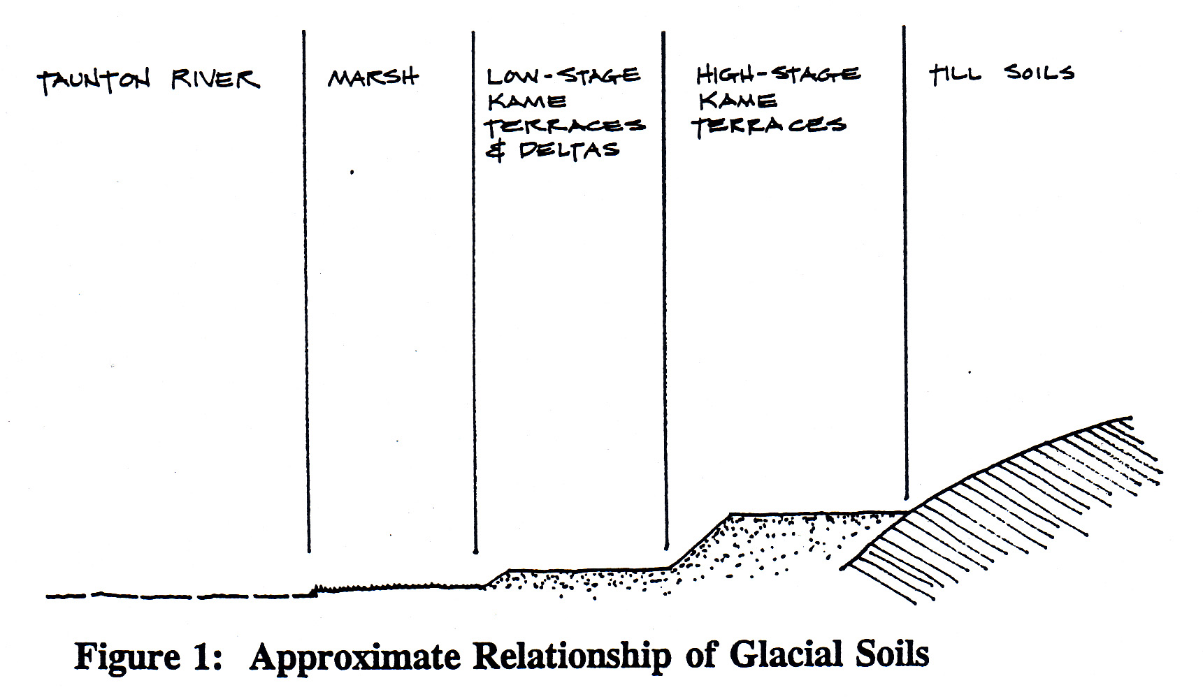
High stage deposits of Glacial Lake Taunton: These high stage deposits were created by the deposition of sand and gravel in layers, forming what is called “kame terraces.”
In Assonet, these flat kame terraces are approximately 168 feet above the elevation of the Taunton River. Further upriver, in Berkley, Dighton and Taunton, the kame terraces are 50 feet above the Taunton River, reflecting a later time of formation when the glacial lake drained to a lower level. Because of their sandy nature, the soils on high-stage kame terraces are thin and dry, making them poor for agricultural uses. Because of their gravel and sand composition, kame terraces are often gravel extraction sites. The extensive gravel pits in Assonet are on kame terraces. One of the most intact kame terraces in the Fall River area has been preserved as part of the Freetown-Fall River State Forest
Low stages of Glacial Lake Taunton: During the later stages of Glacial Lake Taunton, finer material was deposited in kame terraces and kame deltas at lower elevations. These soils later became prime agricultural soils for Native populations because they were not stony and difficult to work like glacial till, not as dry as the high-stage kame terraces, and not too wet like lower-stage soils. These low-stage kame terraces and kame deltas were easily cultivated by native tribes with tools made of stone, bones and shells. They also became the prime soils for the thriving agricultural economy that was later initiated by the Europeans who settled the Taunton River watershed.
Finally, the end of Glacial Lake Taunton is shown in the low wetlands, swamps and marshes that are also characteristic of the watershed. The largest of these swamps is the extensive 16,950-acre Hockomock Swamp in Bridgewater and surrounding towns. Salt and fresh water marshes along the edge of the river are low-stage deposits that became important wildlife habitats and therefore important to native tribes for hunting and to the Europeans for harvesting hay for winter fodder for cattle.
See the Figure 1 for the relative levels of soil formations in the Taunton River watershed that resulted from the last Ice Age:
Formation of Ponds and Wetlands: Glacial outwash soils are characterized by many interesting land formations of historical interest. In addition to kame terraces---with their flat tops and steep ice contact slopes---outwash soils include formations such as kettle holes and eskers.
Kettle holes---often circular, but irregular for larger formations, and either dry or with standing water---are depressions characterized by steep ice contact slopes. Kettle holes were formed when isolated ice blocks of various sizes broke off of the main glacier and were stranded in glacial lakes. Sand and gravel deposits continued to be deposited around the stranded ice block and, when the lake drained away, the isolated ice block melted, resulting in the collapse of the gravel face abutting the ice block and leaving the kettle hole. Figure 2 is a graphic illustration of how kame terraces and kettle holes were formed.
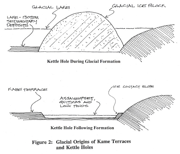
Small kettle holes exist in the upper reaches of the Taunton River and in the coastal formations in Plymouth and Wareham. Perhaps the most famous of the larger kettle holes in New England is Walden Pond in Concord, a remnant of Glacial Lake Concord. The most significant kettle holes that remain from Glacial Lake Taunton are the great ponds in Lakeville and Middleborough at the headwaters of the Taunton River: Long Pond, Assawompsett Pond and Great and Little Quitticas Ponds.
North and South Watuppa Ponds are also probably kettle holes, since they are naturally- occurring and their sources are spring-fed. In addition, historical information suggests that the kame terraces that would have been on their shores have been mined for gravel for at least 80 years during the building of Fall River and therefore have long since disappeared. The last remnants of the once extensive kame terraces on the North Watuppa shoreline were mined for gravel during the construction of Route I-195 in the early1960’s. The secondary benefit was to have been the increase in holding capacity of the pond. Cook Pond may have also been a kettle hole, but the identifying kame terraces that would conclusively identify it as such may have been destroyed and removed during the 19th century. Most of the ponds in Fall River have a north/south axis, in the direction of the receding glaciers that formed them.
Wetland areas within the Taunton River watershed are usually part of a remnant of a glacial era drainage system or ancient ponds that have eutrophied and filled in with sediment, peat and vegetation. In some instances, wetlands began as kettle hole ponds. This appears to be the case with the Pocasset Cedar Swamp in Tiverton and Fall River. This swamp feeds the ponds that flow into the Quequechan River.
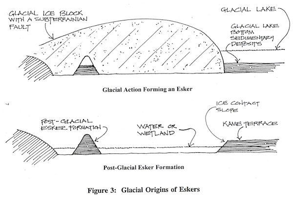
One of the more unusual and rare formations remaining from the last Ice Age are eskers. Eskers are elongated, serpentine hills of about 30 feet in height that were formed when fissures in glacial ice blocks allowed underground streams to course through the glaciers over thousands of years, depositing layers of gravel and boulders. When the glaciers melted, esker formations resulted. How eskers were formed is illustrated in Figure 3. Since eskers are valued for their gravel, most have been used as gravel pits and destroyed during the last 100 years. Few eskers remain in the Fall River area; however, one has been preserved in the Freetown-Fall River State Forest and another extends into the Taunton River north of the mouth of Mothers Brook at Barnaby’s Cove.
Tributary Stream Characteristics:
The main tributaries that flow into the Taunton River in Fall River are Mother’s Brook, Steep Brook and the Quequechan River.
Mothers Brook: Mothers Brook drains an area of approximately 8 square miles and has a fall of 49 feet. Its headwaters are in the corporate boundaries of Fall River but it enters the Taunton River in Freetown. Mothers Brook was an important Native American settlement area for three main reasons: (1) because the fertile and easily cultivated low- stage kame terrace and kame delta soils in the area made agriculture productive; (2) because the brook was the route for a spawning area for herring in the spring, which made it a productive site for a fish weir; and (3) because of its location on the Taunton River, which was used for travel and trading.
Archaeological excavations conducted by Roy Athearn of Fall River showed that PaleoIndian settlement along the mouth of Mothers Brook occurred there about 11,000 years ago, shortly after the end of the last Ice Age. Mr. Athearn collected over 13,000 artifacts along the Taunton River during his many years of collecting, from sites extending from Barnaby’s Cove and Peace Haven to the Berkley-Dighton Bridge. The artifacts discovered by Mr. Athearn are now on display at the Somerset Historical Society.
Mothers Brook remained a pristine brook until the development of the landfill at the headwaters of the brook. As the unlined landfill expanded, it filled in the headwaters and polluted the groundwater and surface waters that flow into the brook to the point where the brook is and will remain polluted and unable to support viable aquatic life.
Steep Brook: Steep Brook drains an area of 6 square miles that includes the Fall River Industrial Park. It has a fall of 67 feet, a factor that led to its harnessing for early saw and grist mills by European settlers. The village of Steep Brook grew up around the stream at the point where it enters the Taunton River.
Quequechan River: The main characteristic of Quequechan River is its dramatic drop within a relatively short distance. The river falls approximately 130 feet within a distance of 2,300 feet. Its watershed includes the North and South Watuppa Ponds, Stafford Pond, a series of smaller ponds and a portion of the Pocasset Cedar Swamp. The flow of the river is 121.5 cubic feet per second. A dam was constructed at the top of the falls that raised the level of the feeder ponds by two feet. The river runs on a granite bed. During the early growth of the textile manufacturing industry, when water power was the only way to power mills, the river was virtually covered with structures. The river was so built up with factories that an early commentary describes the banks a being “entirely built up with large manufacturing establishments, which so rapidly succeed each other as scarcely to leave space between some of the buildings sufficient for light and air.”
With the construction of Interstate Route 195 over the Quequechan River in the 1960’s, the river was briefly opened and then again entombed for much of its length in a massive culvert. However, an effort is underway by Green Futures to liberate and “daylight” the river from its current enclosures.
Fish of the Taunton River:
Fish populations: Surveys conducted in 1969 and 1970 by the Massachusetts Division of Marine Fisheries recorded 45 species of fish in the Taunton River and Mount Hope Bay. The most abundant species was the Atlantic silverside, followed by the Atlantic menhaden, Winter flounder, striped killifish, white perch, weakfish, Atlantic tomcod and windowpane. Striped bass, Atlantic mackerel, bluefish and weakfish were more common than the data indicated, but were taken infrequently because of the selectivity of the gear used in sampling..
Anadromous fish species: The Taunton River has the largest anadromous fish run in Massachusetts. Anadromous fish are fish that spawn in fresh water and mature in the sea. The most numerous of these anadromous fish in the Taunton River are alewives (or river herring); the river has supported one of the largest and most famous alewife fisheries in the United States.
The anadromous species in the Taunton River that spawn in the headwaters of the river’s tributary streams include alewifes, American shad, Atlantic sturgeon, white perch, blueback herring, rainbow smelt, sea lamprey and striped bass.
Alewives were once very numerous in the Taunton River and the source of a thriving commercial fishing industry along the river. The construction of dams along tributary streams for industrial purposes and the effects of pollution have resulted dramatic reductions of alewife populations in the river. However, with the introduction of fish ladders on the tributaries of the Taunton River, anadromous fish species are making a comeback on the river.
Catadromous fish species: Unlike anadromous species, catadromous fish species live and mature in fresh water but spawn in the sea. American eels are a catadromous species that live in the Taunton River and its tributaries.
Sportfishing: The Taunton River and Mount Hope Bay provides opportunities for sportfishing for a wide variety of finfish species, including striped bass, bluefish, weakfish, white perch, tautog, winter flounder, American eel, northern kingfish and Atlantic tomcod.
In the Fall River area, the most popular spots on the Taunton River for fishing for striped bass are under the Brightman Street Bridge, at the former site of the Slades Ferry Bridge and various wharves along the river. Fishing is also conducted from boats launched from the Brownell Street boat ramp in Fall River, the Brayton Point and Riverfront Park ramps in Somerset, the ramp at Hathaway Park in Assonet on the Assonet River, and in Dighton at Whale Rock. Most striped bass fishing occurs between mid-April and mid-November. Bluefish arrive in the area in late May or early June and are taken in many of the same locations.
In recent years, the population of winter flounder has decreased substantially from over- fishing and from an increase in water temperatures in Mount Hope Bay from heated water discharges from the Brayton Point Power Plant. The northern kingfish has also decreased in population due to overfishing in the Middle Atlantic states. However, migratory fish, such as striped bass and bluefish, are still abundant in the Taunton River.
Historical Commercial Fisheries:
Herring fisheries: The Taunton River and its tributaries were once home to annual runs of herring. Herring were so profitable that towns on the river sold fishing rights annually at auction. In his History of Fall River, Arthur Phillips says that “few of the herring were eaten fresh but were corned for future use. During the ‘herring-run,’ every grocery and general store had outside the doorway a rack of corned herring, which were hung from sticks thrust through the eyes and were sold for a few pennies each.” The herring were so numerous that they were used for fertilizer. Salted herring were exported to the West Indies and southern colonies as inexpensive food for slaves.
Menhaden: Menhaden, often referred to as pogies, are of little use for human consumption. However, in the 18th and 19th centuries, local fishermen dressed, salted and shipped them in considerable quantities to plantations in the West Indies and southern colonies, very likely to feed the slave populations there. In 1878, the firm of Joseph Church and Sons built a factory at Common Fence Point to manufacture Menhaden oil and fertilizer. The business prospered and at times employed 250 men during the fishing season.
Sturgeon: Before they became virtually extinct in the Taunton River, sturgeon as large as several hundred pounds were not uncommon here. Being andromous fish, the sturgeon ran up the river and its tributaries to spawn in fresh water. They were caught by native tribes and early European settlers at night with spears by torchlight. While the roe from sturgeon is now highly prized, historically the roe was used by locals for bait or to feed hogs.
Shellfish of the Taunton River:
The principal commercial shellfish in the Taunton River and Mount Hope Bay area are quahogs, soft-shelled clams, oysters and mussels. Blue crab and horseshoe crab are also common species in the estuary. During the late 1800’s, an oyster harvesting industry flourished in the Taunton River and Mount Hope Bay areas, producing in 1897 one of the finest oysters in the state. These were exported to markets as far away as New York City. However, by 1907, the Taunton River had become so polluted that the oysters could no longer be marketed.
Because shellfish absorb concentrations of pollutants to a greater degree than finfish, shellfish in the Taunton River became inedible as the river became more polluted.
The upper freshwater section of the river is the habitat for seven species of freshwater mussels, making it one of the most diverse waterbodies in the state for this rare group of animals.
Waterfowl, Shorebirds and Mammals on the Taunton River:
The Taunton River is the habitat for a wide range of birds and mammals. Some of the more common are:
Herring Gulls
Great Black-Backed Gulls
Ring-Billed Gulls Laughing Gulls
Common Tern Semi-palmated Sandpiper Least Sandpipers
Spotted Sandpiper
Greater Yellow Legs
Lesser Yellow Legs
Black Crowned Night Heron Blue Heron
Green Heron
Snowy Egret
American Egret
Wintering Bald Eagles
Wintering ducks: Common Goldeneye, Greater Scaup, Red-Breasted Mergansers and Bufflehead.
Resident ducks: Mallard Duck, Black Duck. Osprey
Double-Crested Cormorant
Kingfisher
Canada Geese Virginia Rail Common Snipe Mute Swan
Mammals that use the river for its habitat include Harbor Seals, River Otter, Muskrats and Mink.
Marine Vegetation of the Taunton River:
Salt marshes: Salt marshes play a very important role in assuring the biological productivity of the Taunton River and Mount Hope Bay estuary and coastal waters. They stabilize the shoreline and are rich in organic nutrients. Salt marshes are prodigious synthesizers of organic matter and essential nutrient salts. Within the estuarine ecosystem, nutrient salts and organic matter produce a complex interaction between nutrients, plants and animals.
The narrow drainage creeks that traverse salt marshes provide natural spawning, feeding and nursery areas for finfish and shellfish. In addition, the sheltered waters and grasses of the tidemarsh provide important nesting and feeding habitats for many species of waterfowl, fish and shellfish.
The Massachusetts Division of Marine Fisheries collected 14 species of plants in the Mount Hope Bay-Taunton River estuary. These included three green algae, two red, one brown and eight species of vascular plants. Most of the 410 acres of salt marsh in the estuary are situated in Dighton, Berkley and Freetown. These marshes are protected under the Massachusetts Wetlands Protection Act.
Historically, salt and fresh water marshes have been important in the settlement patterns of native tribes and European settlers. The native tribes burned the marshes annually to increase their productivity of grasses and therefore the population of wildfowl for hunting. The Europeans also continued the practice of burning the marshes to increase the production of grasses, but for the purpose of harvesting the grass for use as winter fodder for their cattle. Today, salt hay is occasionally harvested for use as mulch in landscaping.
A Commentary by Everett Castro on Historical and Current Fishing and Shellfishing on the Taunton River:
Recreational fishing is a very popular activity on the Taunton River. The middle river, at the head of the tide at Taunton, is unique in that an angler can often be surprised by catching what are predominantly salt water fish on the incoming tide and on the outgoing find himself hooked into a freshwater species such as a largemouth bass or a carp. In the freshwater reaches of the Taunton River, upstream of Taunton, largemouth bass would be the predominant game fish. The largemouth bass, introduced to Massachusetts in the late 1800’s, share the middle and upper river with native redbreast, pumpkinseed, and banded sunfish; chain pickerel; white and yellow perch; brown bullheads; white suckers; and introduced species such as bluegill sunfish, carp, and black crappie. Native brook trout, severely impacted by agricultural development and the later industrial revolution are still present in small numbers in a few Taunton River tributaries that contain the cool, well- oxygenated water required by this delicate species.
Most of the recreational anglers on the middle and upper Taunton River target the largemouth bass as their principal quarry.
Recreational fishing in the lower Taunton River, the estuarine portion, is focused almost entirely on the premier New England game species, the striped bass. When present, summertime fishing for bluefish and squeteague is also popular. These latter two species are migratory and their comings and goings are difficult to predict. The squeteague, known as weakfish or sea trout in the Middle Atlantic States, have been overfished offshore and are not as common in the Taunton River as they used to be.
Subsistence fishermen, mostly Southeast Asian and Portuguese, and a few recreational “meat” anglers target resident fish species. Tautog, white perch, American eels, tomcod, and northern scup are a few fish species that are seasonally abundant in the Taunton River. Until fairly recently, winter flounder were one of the most popular species. They were much sought after by both recreational and commercial fishermen up until the early 1980’s when the population crashed. Presently, winter flounder fishing is banned in the Taunton River, but the population shows little sign of recovery.
Commercial fishing activity in the Taunton River is presently centered on white perch, American eel, and menhaden. Ark Bait, located in Fall River on the waterfront north of Steep Brook, is one of the principal commercial operations targeting the menhaden schools. Local menhaden are harvested for sale to commercial and recreational fishermen as bait for lobster pots or game fish. Although not as abundant as formerly, when schools are present in Mount Hope Bay and the Taunton River one can often see the “fish spotter” planes circling over the Taunton River. These planes are used by the commercial operators to locate and report back to the boats the location of the surface swimming menhaden schools.
Eels are caught in eel traps and, if small, they are sold as bait to recreational striped bass fishermen; if large, they go to the fresh fish market. Eels were very plentiful in all New England rivers and streams and are another species presently suffering from overfishing. At Plymouth Plantation, the historic re-creation of the first Plymouth settlement, one can see wicker eel pots or traps hanging on the walls of virtually every house. Eels were more highly prized than lobster or most other seafood in New England until fairly recent times. Some ethnic groups prize eels especially during the Christmas holiday season.
The eel also supported a unique winter fishery. At that time of year the eels are hibernating in large coiled masses in the muddy bottom of river coves under five to fifteen feet of water. Fishermen would have to wait until winter ice formed of sufficient thickness to support their weight and then they would cut holes through the ice above the hibernating eels and using a specially equipped spear with recurved tines, snag the eels out of the mud. The eel, dormant in hibernation, would be deposited on the ice and the spear returned for another member of the hibernating group. Eels would hibernate in the same location each winter and prime eeling spots were handed down from father to son and arguments over “eel territory” were common on the Taunton River in the wintertime.
For thousands of years, the Taunton River has hosted the largest spawning runs of alewife. Alewifes are a type of anadromous herring. In Massachusetts, Indian fish weirs were located at numerous shallow water sections from tide water upstream to the Nemasket River tributary. These weirs captured not only alewives, but also the closely related blueback herring and American shad. The Wampanoag Indians’ New Year is still celebrated at the time the “herring return to the rivers”. Industrialization and the accompanying dams and pollution all but wiped out these incredible fish runs. Today, they are making a dramatic comeback with many communities and sportsmen’s clubs constructing fish ladders on the many Taunton River tributaries so that the herring can reach their ancestral spawning grounds in the headwaters of their natal streams.
With the completion of many of these fish ladders, and with improving water quality, the restoration of shad in the Taunton River is being supported by the Massachusetts Division of Fish and Wildlife. Small numbers of Atlantic shad, hickory shad, and gizzard shad are now found in the Taunton River at their particular season.
Pollution and overfishing, as in most other east coast rivers, all but eliminated the Atlantic sturgeon as a viable species by the late 1700’s. Truly amazing fish, sturgeon are among the oldest of living fishes. They first appeared in the fossil record over sixty million years ago. Growing slowly and reaching an amazing fourteen feet and almost a thousand pounds in weight, sturgeon do not reach sexual maturity until nearly twenty years old. It didn’t take long before the sturgeon fishery would be but a faint memory among Taunton River fishermen. Amazingly enough, a few are pulled from the Taunton River every year by surprised fishermen, but as an endangered species must be returned to the water immediately. Although it would take much longer than a human lifetime, it would be wonderful to see the Atlantic sturgeon fully restored in the Taunton River.
Two species that are not recorded as living in the Taunton River, but were probably present at one time, are Atlantic salmon and diamondback terrapin. Salmon, being remarkable fish and eminently edible, left an indelible impression on the early Europeans. Historic salmon waters, from the Connecticut River north usually have place names with the word “salmon” in them. “Salmon Falls”, in Vermont, “Salmon River”, in Connecticut, “Salmon Rock” in Maine, etc. Although there aren’t any “salmon” place names and little salmon habitat along the slow flowing, low gradient Taunton River, there are a few tributaries, such as the Nemasket, that before European settlement, dams, pollution, and overfishing must have been suitable Atlantic salmon spawning waters.
The diamondback terrapin is a reptile, but was once held in higher gustatory esteem than many fishes. During the terrapin eating fad, in the mid to late eighteen hundreds, terrapins were fetching prices as high as twenty-four dollars apiece at Fulton’s Fish Market in New York City. Sought after by the wealthy for fancy dinner parties from Newport, Rhode Island to Charleston, South Carolina, it didn’t take long until this slow- growing marine turtle was all but extinct over most of its native range. The Taunton River no doubt had many terrapins during Colonial times and there is today, one last heavily guarded diamondback terrapin colony in the Barrington River, a tributary to Narragansett Bay, just a few miles from the Taunton River.
Finally, although not finfish, northern quahogs, horseshoe crabs, and channeled whelks are harvested commercially from salt water portions of the Taunton River. Although all shellfish are off-limits because of bacterial and heavy metal contamination in the Taunton River, the Massachusetts Division of Marine Fisheries has periodically allowed northern quahogs to be harvested from the river for transplanting to various Cape Cod communities where the quahogs are then released to purify themselves over time and allow for later harvest by town shellfishermen. The horseshoe crabs are taken for eel bait by commercial eel fishermen and by those that remove their blood for sale to medical laboratories and return the crabs to their environment. Channeled whelks are captured in traps, similar to lobster or crab pots, and sold to fish purveyors and restaurants to be turned into “conch salad” highly regarded by local Italian-Americans. Because the whelk viscera is discarded, and not eaten as in other shellfish, channeled whelk harvest is allowed in the Taunton River.
There is also some harvesting of soft-shell clams, fiddler crabs, green crabs, and seaworms, by seasonal fishermen, from the tidal portions of the Taunton River. They sell their catch to local bait and tackle shops for fish bait.
<Back
Social