Current Projects
Chapter 5 - The Challenge for Today and Appendices
The Taunton River today is in many respects unchanged. It still flows down from its headwaters, fed by its tributaries and still ebbs and flows with the tides where it becomes an estuary. It continues to be used for transporting freight (coastal freighters deliver goods and raw materials to the State Pier in Fall River and colliers bring coal to the power plant at Brayton Point) and ships are still being built on its shores (passenger ferries and pleasure boats are built in Somerset, the former at Gladding-Hearn and the latter at Fortier shipyards; tug boats are built in Fall River off of Davol Street). Limited commercial fishing is also still active on the river.
However, the Taunton River today is valued mostly as “open space,” for the scenic beauty that it adds to the communities that border on it. It is also valued for its recreational potential, principally recreational boating and fishing.
The river has come to be valued as an end in itself, rather than as a means to some other end. It has benefited from the national environmental movement that resulted in the passage of the Clean Water Act.
There are two principal challenges to the Taunton River: (1) protecting the quality of the river’s water; and (2) protecting the scenic quality of the shoreline.
Improving the Water Quality of the Taunton River
The 1972 federal Clean Water Act has resulted in court orders to reduce pollution resulting from untreated sewage that enters the river when heavy rains occur. Because sewer and storm drains are combined throughout most of the city, the sewage treatment plant becomes overtaxed during heavy storm events, resulting in the release of untreated sewage. The City of Fall River is nearing completion of a project to construct an underground storage detention system that will catch and hold stormwater and sewage during major storm events and gradually release it to the sewage treatment plant for processing. This solution to the ongoing combined sewer overflow situation will cost the City over $150 million.
Mother's Brook has been degraded by being channelized and has been polluted by ground and surface water originating from the Republic Services Dump and surrounding industrial land, located at the headwaters of the brook. The early stages of the landfill did not have liners under the fill. The landfill extends to the brook and with the filling of Phase 3 of the landfill expansion almost complete, Mother's Brook now flows through a valley of trash rising above either side of it.
Protecting the Scenic Quality of the Taunton River Shoreline.
The second challenge for this generation related to the Taunton River---and one in which every citizen can easily participate---is the protection of the scenic quality of the river and we are happy to report that the challenge has mostly been met when in 2009 the Taunton River was declared a National Wild and Scenic River by the U.S. Congress.
Other challenges remain. It is important to preserve the natural shoreline of the river along those areas remaining undeveloped in the far northern section of Fall River and Assonet, Berkley and Dighton.
In Fall River and Assonet, the most important challenge is the protection of the area around “Peace Haven” north and south of the mouth of Mother's Brook. This is the area where Roy Athearn and his associates discovered artifacts that confirmed that this site has been inhabited for 11,000 years, first by Paleo-Indian tribes and continuously since that time. This site deserves permanent protection from destruction by inappropriate development.
Peace Haven also has the distinction of being the site of the ancient Indian ferry that operated from Winslow’s Point. From this location, King Philip and Weetamoe crossed the Taunton River on July 19, 1675 following the battle with the English in the Pocasset Swamp in Fall River and Tiverton and made their escape along the Mowry Path.
In addition, the elongated peninsula that juts out into the Taunton River north of the mouth of Mother's Brook, forming Barnaby’s Cove, is an esker, a rare geologic land formation that remains from the last Ice Age.
The significance of the Peace Haven landscape requires that it be protected from inappropriate development. At the very least, the viewshed from the river should be protected by preserving a wide swath of undisturbed land that will also preserve the invaluable archaeological and historic sites at this location.
In Fall River, the shoreline north of Steep Brook retains a scenic quality because of the open space provided by the Fall River Country Club and by the undeveloped land below the railroad tracks north of the Country Club. The land north of the golf course is recommended for preservation in the City’s Open Space and Recreation Master Plan.
The Taunton River Watershed Alliance is advocating for the creation of a greenway along the entire length of the river. This greenway would preserve the scenic shoreline of the river, including the archaeological sites that are concentrated along the shore.
Green Futures strongly endorses this greenway effort and, in addition, is recommending that the Taunton River Greenway be connected to the Southeastern Massachusetts Bioreserve via a possible connection at Peace Haven. This greenway connector would not only provide a physical connection between the 15,000-acre Bioreserve and the Taunton River Greenway but it would assist in the protection of the archaeological, historical and geological sites and integrity of Peace Haven.
The Taunton River is a tremendous asset to Southeastern Massachusetts. It is rich in natural qualities, in history and in recreational potential. It is our shared common heritage.
Appendix A:
Summary of the Taunton Heritage River Guide and Reference Map
Introduction
This Summary Guide to the Taunton Heritage River was prepared as a companion to The Taunton Heritage River Guide. Both the summary and the full guide were prepared by Green Futures as part of a grant from the Taunton Heritage River Program, an initiative of the Massachusetts Executive Office of Environmental Affairs and its Riverways Programs.
The numbers at the beginning of each section refer to the numbers on the map. The numbers in parentheses at the end of each entry identify the page number of the full guide, where more information on the topic or location can be found.
The Taunton Heritage River Guide and this summary were prepared to increase the public’s appreciation of the Taunton River in Fall River. It is meant to be a guide for those who wish to explore the river and its shoreline and as a curriculum resource for local schools.
***************************
1. Falls of the Quequechan River: The river has a fall of 130 feet within a lineal distance of 2,300 feet. Early grist, saw and fulling mills were located on the falls. Later, its water power and location on a navigable waterway (Taunton River and Mount Hope Bay) resulted in its being the location of textile mills and the growth of Fall River as a major textile manufacturing center. The Quequechan River was ideal for water powered-mills because it had adequate flow of water to power mill machinery yet was modest enough to protect against flooding; its granite bed allowed mills to be built right over the river, and its water rights were owned by one family (8, 39, 45).
2. Fall River Iron Works: Established in 1821, the Iron Works made hoops for New Bedford’s whale oil casks, castings for machinery and nails. Its markets were within 20 miles of Fall River, but included New York City and up the Hudson River.The capital from the Iron Works helped to develop the Fall River Line, textile mills, a textile machinery company, the gas company and other waterfront developments (49).
3. Fall River Line Pier: The Fall River Line provided direct passenger and freight service from Fall River to New York City from 1845 to 1936. The “floating palaces” of the line were a significant factor in Fall River’s ascendancy as a textile center, providing overnight service for the delivery of finished textiles from Fall River to New York (53).
4. Terry shipyard dry dock: The shipyard of Joseph C. Terry built many passenger and freight sailing and steam vessels at this location. Terry and James Hood built some of the fastest and most famous clipper ships of the 1850’s in Hood’s shipyard on the Taunton River in Somerset Village (51).
5. Salt Works: In 1777, the Town of Freetown voted to establish a salt works along the Taunton River, after the Revolutionary War cut off supplies of salt from the West Indies. The works was at the current site of the Mechanics Mill on Davol Street (41).
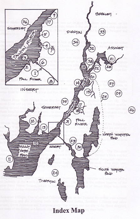
6. Wood Slide: Wood for fuel and lumber was cut in East Fall River and floated on the Quequechan River to the edge of the steep hillside, where it was placed on a wood slide and sent to waiting sloops at the base of the falls. From there, it was delivered to Bristol, Newport and other towns (42).
7. Benjamin Church House: At the corner of June and French Streets, this is perhaps the oldest house in the city, built by Benjamin Church. Church led the local militia during King Philip’s War and ended the war by capturing King Philip or Metacomet (27).
8. Skeleton in Armor: The Skeleton in Armor was excavated from an embankment on the shores of the upper Quequechan River at Hartwell Street in 1832. The skeleton gave romantic poet Henry Wadsworth Longfellow the idea to write the poem, “The Skeleton in Armor,” linking the skeleton with the stone tower in Newport and legends of Viking explorers in Mount Hope Bay (24).
9. Slades Ferry: From 1678 to 1877, the Slade and Brightman families operated the Slades Ferry where the Brightman Street Bridge is now located. The ferry evolved from rowboats, to sail boats, to horse-driven boats and then steam boats. It carried the Providence stages across the Taunton River to and from Fall River and New Bedford (50).
10. Mount Hope Bay: Mount Hope Bay has historically been a productive fishery (8). The Taunton River and bay provide opportunities for sportfishing for a wide variety of finfish species, including striped bass, bluefish, weakfish, white perch, tautog, winter flounder, American eel, northern kingfish and Atlantic tomcod. In recent years, the Bay has suffered a dramatic loss of fish populations due to the cooling tower systems at the Brayton Point Power Plant (56).
11. Mount Hope: This drumlin formation in the Town of Bristol was the seat of the Pokanoket tribe of the Wampanoags, the principal tribe of the nation. Here, King Philip had his seat (16). Some evidence indicates that the Vikings settled at Mount Hope in the years 1000 to 1007. Legend has it that Leif Erickson visited Mount Hope in 1000 and that his brother Thorfall visited the area in 1007, where his wife bore him a son, Snorre, believed to be the first European born in the New World (24).
12. Gardner’s Neck: Gardner’s Neck, part of the Pocasset territory (16). The Pocassets operated a ferry here at the southern tip of the neck to Mount Hope (21). Gardner’s Neck was the scene of the start of King Philip’s War, when, on June 20, 1675, several Pokanoket warriors crossed the Kickamuit river and looted several English homes on the neck. Four days later, Pokanokets killed seven settlers on Gardner’s Neck in retaliation for the settlers killing of a Pokanoket (27).
13. Brayton Point: The Braytons were one of Somerset’s early families and later one of the major builders of the textile industry in Fall River. The point is the current location of the Brayton Point Power Station, which is causing thermal pollution of Mount Hope Bay, with destruction of the bay fisheries (56).
14. Somerset Village: One of several Colonial villages on the Taunton River that were centers of shipbuilding and the shipping trade with the West Indies, Southern Colonies and other American, South American and European ports. The village was the site of the Hood shipyard, where some of the fastest and famous clipper ships of the 19th century were built.
15. Taunton River fisheries: The Taunton River historically has had the largest anadromous fish run of any river in Massachusetts, the most numerous being alwifes or river herring. Today the Taunton River is a productive sport fishing area (8).
16. Steep Brook: One of the three main tributary streams of the Taunton River in Fall River. Steep Brook Village grew up around the stream (8, 34).
17. Steep Brook Village: Along with Assonet and Fall River (at the Quequechan), Steep Brook was one of the principal villages of Freetown during the Colonial era and later. It was one of the centers on the Taunton River of the West Indies trade and trade with the Southern Colonies and many coastal communities. Steep Brook was at the crossroads of the stagecoach routes between Boston and Newport/New York and Providence and New Bedford and was the site of the Green Dragon Inn, a stopping place along the stage coach routes (34).
18. Chace’s Ferry: At the bottom of Wilson Road in Steep Brook, Chace's Ferry carried passengers across the Taunton River from Somerset and Dighton who wished to connect with the stagecoaches to Boston, Newport, New York and New Bedford.
19. Mothers Brook: One of the three main tributaries of the Taunton River in Fall River. It was the site of native American settlement for approximately 11,000 years. It supported annual herring runs, where the native tribes placed fish weirs (6). In modern times, Mothers Brook has been polluted from groundwater contamination resulting from the landfill at its headwaters (56).
20. Peace Haven: Site of the Indian Ferry at the end of Mawry’s Path at Winslow’s Point on the Taunton River. Peace Haven is also the site of recorded 11,00 years of settlement of native tribes, ending with the Pocassets in the Colonial era (6). It is also the site of a rare esker, a geologic formation created in Glacial Lake Taunton (6).
21. Assonet Village: The principal village of Freetown in the Colonial and Federal periods. It was a center of shipping and shipbuilding on the Taunton River. Its trade extended with the West Indies, Southern Colonies and beyond (31).
22. Assonet River: One of the principal tributaries of the Taunton River, it provided a protected harbor for the development of Assonet Village (31).
23. Quequechan River: This river, located at the edge of navigable waterways, became the reason for the development of Fall River as a textile center. Its modest flow, bedrock foundation and location next to navigable waterways made it ideal for the development of the smaller Rhode Island-type factories (8, 39, 45).
24. Pocasset Cedar Swamp: A major swamp spanning the Fall River/Tiverton border and headwaters of Cook Pond and the Quequechan River. On July 19, 1675, the swamp was the site of a battle between Pocasset and Pokanoket warriors and an English militia, resulting in the retreat of King Philip and Weetamoe’s forces along Mawry’s Path to the ferry at Winslow’s Point and across the Taunton River.
25. The Mawry Path: An old Pocasset path on the eastern shore of North Watuppa Pond that led from Tiverton north to the Taunton River. It was the route of escape of King Philip’s and Weetamoe’s forces from the battle of the Pocasset Cedar Swamp (21).
26. East Fall River: Because of its unsuitable soils for agriculture, East Fall River became a woodlot for the growing coastal communities. Wood for fuel and lumber was brought by boats along the Watuppa Ponds down the Quequechan River to the wood slide on the hillside at the falls and slid to waiting boats for transport to coastal towns that lacked wood (42). The area is now the site of the 15,000-acre Southeastern Massachusetts Bioreserve.
27. Kame Terraces in the State Forest: Kame terraces are unique geologic formations formed in Glacial Lake Taunton along the Taunton River. An undisturbed terrace is located in the state forest (3).
28: Kame terraces in Assonet: Assonet has extensive kame terraces; however, many of these have been mined for sand and gravel for many years. Kame terraces in the state forest and Assonet are uniformly 165 above sea level (3).
29. Glacial boulder field in the Bioreserve: The retreat of the glaciers several thousand years ago left parts of the landscape strewn with boulders. These landscapes were “cleaned up” by settlers and the boulders used to make stone walls. However, stone fields as the glaciers left them are still visible in the Southeastern Massachusetts Bioreserve in East Fall River (3).
30. Glacial erratic: Some of the larger boulders left by the glaciers are visible mostly in the Bioreserve; however, a glacial erratic was left at the intersection of County and Eastern Avenue and named “Rolling Rock”(3).
31. Outlet of Glacial Lake Taunton: When Glacial Lake Taunton finally drained, its outlet was at Fall River. Glacial Lake Taunton, formed by the melting of hugh glacial ice blocks, at one time extended from Fall River to Bridgewater on the north, Mansfield and Norton on the west and Plymouth on the east (2).
32. Dighton Rock: Located in Berkley on the Taunton River, Dighton Rock has inscriptions that link it to a fishing captain and explorer named Miguel de Cortereal, who left Portugal in 1502 and never returned. Inscriptions in the rock have at various times been ascribed to Phoenicians, Vikings and even Captain Kidd. The site is now a state park (25).
33. Low stage kame terraces in Berkley: While high-stage kame terraces in Fall River and Assonet are uniformly 165 feet above sea level, terraces in Berkley and Dighton are uniformly 50 feet above sea level (3).
34. Dighton: Site of shipbuilding and shipping activity on the western shore of the Taunton River. With Assonet, Steep Brook and Somerset Village, Dighton served the West India and Southern Colonies trade as well as other ports (31).
35. Native path along the Taunton River: One of the major native paths once existed along the eastern side of the Taunton River, approximately where Route 138 is now located (23).
36. Brayton Point Shipyards: Site of the Reed Brothers Shipyard, later the Crowninshield Shipbuilding Corporation. From this shipyard were built such impressive four-masted schooners as the Luther Little II and the Hesper for Boston shipping interests, plus many other sailing freighters of the 19th and early 20th Centuries. This site still remains a location for shipbuilding. The Gladding-Hearn Shipbuilding, Duclos Corporation build a great variety of ships here, including passenger ferries, pilot and patrol boats, fishing boats, yachts, barges and many other vessels. Also located here is the Fortier Boats company.
37. Tugboat building yard: Located on the Taunton River on Davol Street in Fall River is dry dock for the construction of tug boats.
38. Taunton River salt marshes: Salt marshes play a very important role in assuring the biological productivity of the Taunton River and Mount Hope Bay estuary and coastal waters. They stabilize the shoreline and are rich in organic nutrients. The narrow drainage creeks that traverse salt marshes provide natural spawning, feeding and nursery areas for finfish and shellfish.
39. Scenic qualities of the Taunton River: One of the challenges for today is to protect the scenic quality of the Taunton River, particularly along the undeveloped sections of the river in Fall River, Assonet, Berkley and Dighton. The Taunton Heritage River Program is an initiative to advance the protection of the river. The Taunton River Greenway is another concept advanced by the Southeastern Planning and Economic Development District (SRPEDD) to raise public consciousness about the need to appreciate the river’s assets and to protect the scenic qualities of the river’s shoreline.
Appendix B: Sources of Maps and Figures
Map 1: Glacial Lake Taunton. Source: unknown.
Map 2: Algonkian Tribes of Massachusetts. Source: Ninnouck: The Algonkian People of New England.
Map 3: Contact Period Core Areas. Source: Historic and Archaeological Resources of Southeast Massachusetts.
Map 4: The Wampanoag Canoe Passage. Source: EOEA’s Taunton River HomePage on the Internet.
Map 5: Contact Period Native Trails. Source: Historic and Archaeological Resources of Southeast Massachusetts.
Map 6: Routes of the Viking Voyagers. Source: The Phillips History of Fall River.
Map 7: Outbreak of King Philip’s War and Metacom’s Escape from Mount Hope. Source: King Philip’s War: The History and Legacy of America’s Forgotten Conflict.
Map 8: Colonial Period Core Areas. Source: Historic and Archaeological Resources of Southeast Massachusetts.
Map 9: Federal Period Core Areas. Source: Historic and Archaeological Resources of Southeast Massachusetts.
Map 10: Steep Brook in 1871. Source: Atlas of Bristol County, MA, 1871.
Map 11: The West End in 1800. Source: Map of Fall River in 1800.
Figure 1: Approximate Relationship of Glacial Soils. Source: Alfred J. Lima
Figure 2: Glacial Origins of Kame Terraces and Kettle Holes. Source: Alfred J. Lima
Figure 3: Glacial Origins of Eskers. Source: Alfred J. Lima
Figure 4: Herring Fishing on the Taunton River. Source: History of the Town of Dighton, MA and History of the Town of Somerset, MA.
Figure 5: Longfellow’s Skeleton in Armor. Source: Various sources.
Figure 6: Workings of a Typical Sawmill on the Quequechan River Powered by Water. Source: Unknown.
Figure 7: Commerce on the Taunton and Quequechan Rivers in Fall River, 1877. Source: Map of Fall River, 1877.
Figure 8: Fall River Line Steamer “Commonwealth.” Source: The Old Fall River Line.
Figure 9: Reductions in Fish in Mount Hope Bay Due to the Brayton Point Power Plant. Source: US Environmental Protection Agency.
Figure 10: Reductions in Winter Flounder in Mount Hope Bay Due to the Brayton Point Power Plant. Source: US Environmental Protection Agency.
Appendix C: References and Further Reading
Anonymous. History of the Town of Freetown, Massachusetts. Fall River, Massachusetts: J.H. Franklin and Company, 1902
Athearn, Roy, Arthur Staples and Carol Barnes. “A Middle/Late Shell Midden at Peace Haven 2.” Bulletin of the Massachusetts Archaeological Society. Boston: Massachusetts Archaeological Society, Inc., October, 1972-Jamuary, 1973.
Athearn, Roy, Arthur Staples and Carol Barnes. “Peace Haven 2: M39-74.” Widening Horizons. Boston: Massachusetts Archaeological Society, April 12, 1980.
Bidwell, Percy Wells and John I. Falconer. History of Agriculture in the Northern United States, 1620-1860. Washington: Carnegie Institution of Washington, 1925.
Brown, Richard D. Massachusetts: A Bicentennial History. New York: W. W. Norton and Company, 1978.
Cronon, William. Changes in the Land: Indians, Colonists and the Ecology of New England. New York: Farrar, Straus and Giroux, 1983.
Curley, John R., et al. A Study of Mrine Resources of the Taunton River and Mount Hope Bay. Boston: Executive Office of Environmental Affairs, August, 1974.
Drake, James D. King Philip’s War: Civil War in New England, 1675-1676. Amherst, Massachusetts: University of Massachusetts Press, 1999.
Emery, Samuel Hopkins, D.D. History of Taunton, Massachusetts. Syracuse, New York: D. Mason and Company, Publishers, 1893.
Hart, William A. History of the Town of Somerset, Massachusetts. Somerset, Massachusetts: Town of Somerset, 1940.
Johnson, Eric S. and Thomas F. Mahlstedt. “The Roy Athearn Collection: A Report from the Massachusetts Historical Commission’s Statewide Survey.” Bulletin of the Massachusetts Archaelolgical Society, April, 1984.
Johnson, Steven F. Ninnouck: The Algonkian People of New England. Marlborough, Massachusetts: Bliss Publishing Company, 1995.
Kurlansky, Mark. Salt: A World History. New York: Walker Publishing Company, 2002.
Lane, Helen S. History of the Town of Dighton, Massachusetts. Dighton, Massachusetts: The Town of Dighton, 1962.
McAdam, Roger Williams. The Old Fall River Line. New York: Stephen Daye Press, 1955.
Massachusetts Historical Commission. Historic and Archaeological Resources of Southeast Massachusetts.
Phillips, Arthur S. The Phillips History of Fall River. Fall River, Massachusetts: Dover Press, 1941.
Rigby, George Oliver. Steep Brook. Danvers, Massachusetts: Bett’s Press, 1979.
Russell, Howard S. A Long, Deep Furrow: Three Centuries of Farming in New England. Hanover, New Hampshire: University Press of New England, 1976.
Schultz, Eric B. and Michael J. Tougias. King Philip’s War: The History and Legacy of America’s Forgotten Conflict. Woodstock, Vermont: The Countryman Press, 1999.
Smith, Thomas Russell. The Cotton Textile Industry of Fall River. Cambridge, Massachusetts: Harvard University Press, 1947.
<Back
Social